Westside Bike Mobility Project
The latest engagement period for this project has ended.

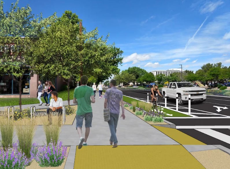
The City of Vancouver began work on the Westside Bike Mobility Project in May 2018. The goal of the project is to establish a multimodal network of north-south Complete Streets to serve the west side of Vancouver (neighborhoods and business districts located west of Interstate 5).
Starting August 2019, the City engaged west side neighborhoods and businesses in examining individual potential Complete Street corridors and identifying a set of improvements that will increase safety and enhance mobility for all users. This phase of the project focused specifically on Columbia, Washington, Daniels and Franklin streets.
The City formed a Community Advisory Committee (CAC) that considered the benefits and tradeoffs of different options, including safety, accessibility, mobility, neighborhood livability and parking. Along with feedback from broader public outreach activities and events in January and February 2020, the CAC helped shape a recommendation to Vancouver City Council about the project.
At the City Council meeting on February 24, 2020, City Council directed staff to implement protected bike lanes and other multimodal improvements on Columbia Street in conjunction with planned repaving projects in 2020 and 2021. At the May 4, 2020, Vancouver City Council meeting, Council postponed repaving on Columbia from 2020 - 2021 to 2021 - 2022, due to impacts from the COVID-19 pandemic on the City’s 2020 Pavement Management Program budget. Funding for the City’s Pavement Management Program has been restored for 2021; therefore, to maximize efficiencies in costs and construction management, pavement work and mobility project implementation for the full Columbia Street corridor are now scheduled for 2021. Please review this memo from January 2021 for more information on the pavement work and mobility project implementation. Staff will be conducting additional public outreach in advance of the repaving. Please sign up at www.cityofvancouver.us/BikeMobility to receive email newsletters to stay up to date as the project progresses.
Thank you to the community members who have participated in Westside Bike Mobility Project events and activities! Feedback received is included in the Phase III Public Outreach Summary.
Learn more about this project at www.cityofvancouver.us/BikeMobility.
Please submit your question about the Westside Bike Mobility Project. Staff will respond as quickly as possible.
-
Share Columbia bike routes remove parking for the Clark County Veterans Assistance Center. For those Veterans that sacrificed so much, appears those same Veterans are penalized. What are the City's plans to preserve parking at the CCVAC if Columbia is selected? on Facebook Share Columbia bike routes remove parking for the Clark County Veterans Assistance Center. For those Veterans that sacrificed so much, appears those same Veterans are penalized. What are the City's plans to preserve parking at the CCVAC if Columbia is selected? on Twitter Share Columbia bike routes remove parking for the Clark County Veterans Assistance Center. For those Veterans that sacrificed so much, appears those same Veterans are penalized. What are the City's plans to preserve parking at the CCVAC if Columbia is selected? on Linkedin Email Columbia bike routes remove parking for the Clark County Veterans Assistance Center. For those Veterans that sacrificed so much, appears those same Veterans are penalized. What are the City's plans to preserve parking at the CCVAC if Columbia is selected? link
Columbia bike routes remove parking for the Clark County Veterans Assistance Center. For those Veterans that sacrificed so much, appears those same Veterans are penalized. What are the City's plans to preserve parking at the CCVAC if Columbia is selected?
CAG15 asked over 5 years agoThank you for your question. We have looked at several design options for this block, including removing parking only on one side and/or providing a drop off/pickup zone in front of the Center.
-
Share Is it the city's position that replacement of parking on Columbia with protected bike lanes will not induce demand for autos on Columbia, shift traffic from Main to Columbia, and cause vehicle speeds on Columbia to increase? This seems counter-intuitive as autos on Columbia will not have vehicles maneuvering for parking and cyclists to contend with. If this is the city's position, is it supported with a traffic study? Residents have been burned badly by unsupported staff opinions, like when we were told the Navigation Center would not lead to an increase in crime in the area. This feels very similar to me. on Facebook Share Is it the city's position that replacement of parking on Columbia with protected bike lanes will not induce demand for autos on Columbia, shift traffic from Main to Columbia, and cause vehicle speeds on Columbia to increase? This seems counter-intuitive as autos on Columbia will not have vehicles maneuvering for parking and cyclists to contend with. If this is the city's position, is it supported with a traffic study? Residents have been burned badly by unsupported staff opinions, like when we were told the Navigation Center would not lead to an increase in crime in the area. This feels very similar to me. on Twitter Share Is it the city's position that replacement of parking on Columbia with protected bike lanes will not induce demand for autos on Columbia, shift traffic from Main to Columbia, and cause vehicle speeds on Columbia to increase? This seems counter-intuitive as autos on Columbia will not have vehicles maneuvering for parking and cyclists to contend with. If this is the city's position, is it supported with a traffic study? Residents have been burned badly by unsupported staff opinions, like when we were told the Navigation Center would not lead to an increase in crime in the area. This feels very similar to me. on Linkedin Email Is it the city's position that replacement of parking on Columbia with protected bike lanes will not induce demand for autos on Columbia, shift traffic from Main to Columbia, and cause vehicle speeds on Columbia to increase? This seems counter-intuitive as autos on Columbia will not have vehicles maneuvering for parking and cyclists to contend with. If this is the city's position, is it supported with a traffic study? Residents have been burned badly by unsupported staff opinions, like when we were told the Navigation Center would not lead to an increase in crime in the area. This feels very similar to me. link
Is it the city's position that replacement of parking on Columbia with protected bike lanes will not induce demand for autos on Columbia, shift traffic from Main to Columbia, and cause vehicle speeds on Columbia to increase? This seems counter-intuitive as autos on Columbia will not have vehicles maneuvering for parking and cyclists to contend with. If this is the city's position, is it supported with a traffic study? Residents have been burned badly by unsupported staff opinions, like when we were told the Navigation Center would not lead to an increase in crime in the area. This feels very similar to me.
DowntownCouver asked over 5 years agoThank you for question. Studies of other similar projects have not shown to increase traffic on streets where parking was removed to provide protected bicycle facilities. The City has completed traffic counts on multiple corridors in the study area and would complete a project evaluation if a route option were to be implemented which would included additional traffic counts to see what, if any changes occurred with the project.
-
Share Columbia south of 19th is zoned for commercial development. Will the city be changing zoning on Columbia, or are there zoning provisions currently in place, to ensure that a building with an underground garage, similar to the nearby Uptown development, can not be sited so that it's garage empties across the protected bike lane? That would be a real disaster / recipe for accidents as the garage would presumably empty and fill back up at rush hour, right when there are the most cyclists in the "protected" bike lane. If there are not zoning provisions in place, it seems like cyclists in this scenario would be about as "protected" as fish in a barrel or ducks in a row. on Facebook Share Columbia south of 19th is zoned for commercial development. Will the city be changing zoning on Columbia, or are there zoning provisions currently in place, to ensure that a building with an underground garage, similar to the nearby Uptown development, can not be sited so that it's garage empties across the protected bike lane? That would be a real disaster / recipe for accidents as the garage would presumably empty and fill back up at rush hour, right when there are the most cyclists in the "protected" bike lane. If there are not zoning provisions in place, it seems like cyclists in this scenario would be about as "protected" as fish in a barrel or ducks in a row. on Twitter Share Columbia south of 19th is zoned for commercial development. Will the city be changing zoning on Columbia, or are there zoning provisions currently in place, to ensure that a building with an underground garage, similar to the nearby Uptown development, can not be sited so that it's garage empties across the protected bike lane? That would be a real disaster / recipe for accidents as the garage would presumably empty and fill back up at rush hour, right when there are the most cyclists in the "protected" bike lane. If there are not zoning provisions in place, it seems like cyclists in this scenario would be about as "protected" as fish in a barrel or ducks in a row. on Linkedin Email Columbia south of 19th is zoned for commercial development. Will the city be changing zoning on Columbia, or are there zoning provisions currently in place, to ensure that a building with an underground garage, similar to the nearby Uptown development, can not be sited so that it's garage empties across the protected bike lane? That would be a real disaster / recipe for accidents as the garage would presumably empty and fill back up at rush hour, right when there are the most cyclists in the "protected" bike lane. If there are not zoning provisions in place, it seems like cyclists in this scenario would be about as "protected" as fish in a barrel or ducks in a row. link
Columbia south of 19th is zoned for commercial development. Will the city be changing zoning on Columbia, or are there zoning provisions currently in place, to ensure that a building with an underground garage, similar to the nearby Uptown development, can not be sited so that it's garage empties across the protected bike lane? That would be a real disaster / recipe for accidents as the garage would presumably empty and fill back up at rush hour, right when there are the most cyclists in the "protected" bike lane. If there are not zoning provisions in place, it seems like cyclists in this scenario would be about as "protected" as fish in a barrel or ducks in a row.
DowntownCouver asked over 5 years agoThank you for your question. There are no current plans as part of the Westside Bike Mobility Project to make any zoning changes in the project area. The City will be updating the Vancouver City Center Vision within the next year that will be looking at land use in the downtown and uptown areas. That project could potentially result in zoning changes in the downtown area but it would be unrelated to the Westside Bike Mobility Project.
-
Share I have scoured the Portland By Bicycle map for protected bike lanes similar to those proposed on Columbia and thus far have not found a single two way street with at-grade bike lanes on separate sides of the street protected by barricades, much less one in an area with driveway and intersection density anything close to what we have on Columbia. Can you please point out where specifically in Portland there is a similar facility? on Facebook Share I have scoured the Portland By Bicycle map for protected bike lanes similar to those proposed on Columbia and thus far have not found a single two way street with at-grade bike lanes on separate sides of the street protected by barricades, much less one in an area with driveway and intersection density anything close to what we have on Columbia. Can you please point out where specifically in Portland there is a similar facility? on Twitter Share I have scoured the Portland By Bicycle map for protected bike lanes similar to those proposed on Columbia and thus far have not found a single two way street with at-grade bike lanes on separate sides of the street protected by barricades, much less one in an area with driveway and intersection density anything close to what we have on Columbia. Can you please point out where specifically in Portland there is a similar facility? on Linkedin Email I have scoured the Portland By Bicycle map for protected bike lanes similar to those proposed on Columbia and thus far have not found a single two way street with at-grade bike lanes on separate sides of the street protected by barricades, much less one in an area with driveway and intersection density anything close to what we have on Columbia. Can you please point out where specifically in Portland there is a similar facility? link
I have scoured the Portland By Bicycle map for protected bike lanes similar to those proposed on Columbia and thus far have not found a single two way street with at-grade bike lanes on separate sides of the street protected by barricades, much less one in an area with driveway and intersection density anything close to what we have on Columbia. Can you please point out where specifically in Portland there is a similar facility?
DowntownCouver asked over 5 years agoThis is a google map image of NE Multnomah in the Lloyd District that has a bike lane in each direction with protection: https://www.google.com/maps/@45.5315356,-122.6595608,3a,75y,100.76h,79.42t/data=!3m6!1e1!3m4!1sPbJCEWU2RkgIAoSXBV_nHQ!2e0!7i16384!8i8192
-
Share We are creating these bike lanes to improve safety. Option #1 will create "protected" bike lanes that cyclists will have to maneuver out of to take left hand turns, and drivers will have to cut across to make turns. Of the auto vs cyclist accidents on Columbia, how many have occurred when either the auto or the cyclist is turning? I'm guessing the percentage is in the high 90's, and the proposed option will do nothing to reduce these accidents; in fact, to the extent Columbia will be much better suited to vehicle traffic under this proposal, the accident rate is likely to spike. Which brings me to my next question: Has the city studied the extent to which this proposal will induce demand for autos on Columbia with wider lanes and no on-street parking? What is the traffic count on Columbia in ten years if we build option #1 vs a no-build option? Because if this project is going to double the traffic on Columbia, it certainly won't do anything for cyclist safety. And if the city hasn't studied induced demand on Columbia because of the changes, I would characterize their handling of this project as extremely careless. on Facebook Share We are creating these bike lanes to improve safety. Option #1 will create "protected" bike lanes that cyclists will have to maneuver out of to take left hand turns, and drivers will have to cut across to make turns. Of the auto vs cyclist accidents on Columbia, how many have occurred when either the auto or the cyclist is turning? I'm guessing the percentage is in the high 90's, and the proposed option will do nothing to reduce these accidents; in fact, to the extent Columbia will be much better suited to vehicle traffic under this proposal, the accident rate is likely to spike. Which brings me to my next question: Has the city studied the extent to which this proposal will induce demand for autos on Columbia with wider lanes and no on-street parking? What is the traffic count on Columbia in ten years if we build option #1 vs a no-build option? Because if this project is going to double the traffic on Columbia, it certainly won't do anything for cyclist safety. And if the city hasn't studied induced demand on Columbia because of the changes, I would characterize their handling of this project as extremely careless. on Twitter Share We are creating these bike lanes to improve safety. Option #1 will create "protected" bike lanes that cyclists will have to maneuver out of to take left hand turns, and drivers will have to cut across to make turns. Of the auto vs cyclist accidents on Columbia, how many have occurred when either the auto or the cyclist is turning? I'm guessing the percentage is in the high 90's, and the proposed option will do nothing to reduce these accidents; in fact, to the extent Columbia will be much better suited to vehicle traffic under this proposal, the accident rate is likely to spike. Which brings me to my next question: Has the city studied the extent to which this proposal will induce demand for autos on Columbia with wider lanes and no on-street parking? What is the traffic count on Columbia in ten years if we build option #1 vs a no-build option? Because if this project is going to double the traffic on Columbia, it certainly won't do anything for cyclist safety. And if the city hasn't studied induced demand on Columbia because of the changes, I would characterize their handling of this project as extremely careless. on Linkedin Email We are creating these bike lanes to improve safety. Option #1 will create "protected" bike lanes that cyclists will have to maneuver out of to take left hand turns, and drivers will have to cut across to make turns. Of the auto vs cyclist accidents on Columbia, how many have occurred when either the auto or the cyclist is turning? I'm guessing the percentage is in the high 90's, and the proposed option will do nothing to reduce these accidents; in fact, to the extent Columbia will be much better suited to vehicle traffic under this proposal, the accident rate is likely to spike. Which brings me to my next question: Has the city studied the extent to which this proposal will induce demand for autos on Columbia with wider lanes and no on-street parking? What is the traffic count on Columbia in ten years if we build option #1 vs a no-build option? Because if this project is going to double the traffic on Columbia, it certainly won't do anything for cyclist safety. And if the city hasn't studied induced demand on Columbia because of the changes, I would characterize their handling of this project as extremely careless. link
We are creating these bike lanes to improve safety. Option #1 will create "protected" bike lanes that cyclists will have to maneuver out of to take left hand turns, and drivers will have to cut across to make turns. Of the auto vs cyclist accidents on Columbia, how many have occurred when either the auto or the cyclist is turning? I'm guessing the percentage is in the high 90's, and the proposed option will do nothing to reduce these accidents; in fact, to the extent Columbia will be much better suited to vehicle traffic under this proposal, the accident rate is likely to spike. Which brings me to my next question: Has the city studied the extent to which this proposal will induce demand for autos on Columbia with wider lanes and no on-street parking? What is the traffic count on Columbia in ten years if we build option #1 vs a no-build option? Because if this project is going to double the traffic on Columbia, it certainly won't do anything for cyclist safety. And if the city hasn't studied induced demand on Columbia because of the changes, I would characterize their handling of this project as extremely careless.
DowntownCouver asked over 5 years agoThank you for your question. The collision data provided by the Washington State Department of Transportation for the years 2015-2017 showed 3 driver/bicycle related collisions on the Columbia corridor. One collision occurred at an intersection where the driver failed to yield the right-of-way to the person riding a bike and the other two collisions did not occur at driveways or intersections.
If protected bicycle facilities were to be added to Columbia Street north of Mill Plain, the travel lane widths would essentially remain the same as the width of the current on-street parking would be replaced by a striped bicycle facility.
-
Share How would City of Vancouver respond to this recent study, which found that protected bike lanes, especially those like the city has planned in option 1 for Columbia, which will cross a great number of driveways, cross-streets, etc, are not always safer for cyclists? https://www.iihs.org/topics/bibliography/ref/2193 This is the exact opposite of what we've heard from city staff, which is that protected bike lanes are a panacea. As usual when dealing with the city, I feel lied to. on Facebook Share How would City of Vancouver respond to this recent study, which found that protected bike lanes, especially those like the city has planned in option 1 for Columbia, which will cross a great number of driveways, cross-streets, etc, are not always safer for cyclists? https://www.iihs.org/topics/bibliography/ref/2193 This is the exact opposite of what we've heard from city staff, which is that protected bike lanes are a panacea. As usual when dealing with the city, I feel lied to. on Twitter Share How would City of Vancouver respond to this recent study, which found that protected bike lanes, especially those like the city has planned in option 1 for Columbia, which will cross a great number of driveways, cross-streets, etc, are not always safer for cyclists? https://www.iihs.org/topics/bibliography/ref/2193 This is the exact opposite of what we've heard from city staff, which is that protected bike lanes are a panacea. As usual when dealing with the city, I feel lied to. on Linkedin Email How would City of Vancouver respond to this recent study, which found that protected bike lanes, especially those like the city has planned in option 1 for Columbia, which will cross a great number of driveways, cross-streets, etc, are not always safer for cyclists? https://www.iihs.org/topics/bibliography/ref/2193 This is the exact opposite of what we've heard from city staff, which is that protected bike lanes are a panacea. As usual when dealing with the city, I feel lied to. link
How would City of Vancouver respond to this recent study, which found that protected bike lanes, especially those like the city has planned in option 1 for Columbia, which will cross a great number of driveways, cross-streets, etc, are not always safer for cyclists? https://www.iihs.org/topics/bibliography/ref/2193 This is the exact opposite of what we've heard from city staff, which is that protected bike lanes are a panacea. As usual when dealing with the city, I feel lied to.
DowntownCouver asked over 5 years agoThank you for your question. The study "Not all protected bike lanes are the same: infrastructure and risk of cyclist collisions and falls leading to emergency department visits in three U.S. cities" had some very good information and recommendations that would be incorporated into the design if a route option were to move forward.
-
Share 100% of the "protected bike lane" examples on this website appear to show protected bike lanes on one-way streets. Can you please point out where protected bike lanes occur on two-way streets, preferably someplace close-by (Portland?), so that we can ride out and see how these work for ourselves? If there aren't any in Portland, maybe research whether there's a reason for that (i.e. they are inherently way too dangerous). https://www.beheardvancouver.org/westside-bike-mobility/photos on Facebook Share 100% of the "protected bike lane" examples on this website appear to show protected bike lanes on one-way streets. Can you please point out where protected bike lanes occur on two-way streets, preferably someplace close-by (Portland?), so that we can ride out and see how these work for ourselves? If there aren't any in Portland, maybe research whether there's a reason for that (i.e. they are inherently way too dangerous). https://www.beheardvancouver.org/westside-bike-mobility/photos on Twitter Share 100% of the "protected bike lane" examples on this website appear to show protected bike lanes on one-way streets. Can you please point out where protected bike lanes occur on two-way streets, preferably someplace close-by (Portland?), so that we can ride out and see how these work for ourselves? If there aren't any in Portland, maybe research whether there's a reason for that (i.e. they are inherently way too dangerous). https://www.beheardvancouver.org/westside-bike-mobility/photos on Linkedin Email 100% of the "protected bike lane" examples on this website appear to show protected bike lanes on one-way streets. Can you please point out where protected bike lanes occur on two-way streets, preferably someplace close-by (Portland?), so that we can ride out and see how these work for ourselves? If there aren't any in Portland, maybe research whether there's a reason for that (i.e. they are inherently way too dangerous). https://www.beheardvancouver.org/westside-bike-mobility/photos link
100% of the "protected bike lane" examples on this website appear to show protected bike lanes on one-way streets. Can you please point out where protected bike lanes occur on two-way streets, preferably someplace close-by (Portland?), so that we can ride out and see how these work for ourselves? If there aren't any in Portland, maybe research whether there's a reason for that (i.e. they are inherently way too dangerous). https://www.beheardvancouver.org/westside-bike-mobility/photos
DowntownCouver asked over 5 years agoThank you for your question. Portland has quite a few streets with protected bike facilities in each direction. Their interactive on-line map is a great resource for identifying which streets have protected facilities: https://pdx.maps.arcgis.com/apps/webappviewer/index.html?id=b51534aa6e1f4dd4ad4d83c4a084d9a6.
-
Share 1 - At any given point in time during the day, there is typically 25-32 cars parked on Columbia between Mcloughlin Blvd and 25th Street. I'd presume these cars park on Columbia, as there is not sufficient off street parking available. I've read the canned response to other people asking this same question. Can you provide specific remedies for those 25-32 cars? 2- From reading the parking load analysis, it appears that 22nd, 23rd & 24th Street, From Columbia to main street would be at 90% capacity. A property owner living on those streets, and/or nearby, would have a 10% chance of getting a parking space near their home. Is this an acceptable metric to the council / committee? Is the loss in property value due to the diminished appeal of not being able to park nearby your home (and/or your guests) acceptable to the council / committee. 3- are any of the council members / committee members directly affected by changes to parking alon Columbia Street? 4- Is the council / committee taking into consideration the parking load the Marijuana store, as well as the Columbia house already has on the neighborhood. The marijuana store is one of the busiest stores in the state with its customers, employees filling the nearby residential streets. Additionally, the Columbia House does not provide parking for all of its residents, nor the care takers who work at the building. Both the marijuana store and the Columbia House put considerable constraints on the current parking situation. Removing parking will only make the parking situation on 21st thru 24th street exponentially worse. Is this being taken into consideration?? As i read the responses to the questions people are asking - i'm seeing the same cut/paste answers. It would be nice to get real solutions to what is could potentially have a significant impact to residents & homeowners along / nearby Columbia Street between 19th and 25th Street. Please advise. on Facebook Share 1 - At any given point in time during the day, there is typically 25-32 cars parked on Columbia between Mcloughlin Blvd and 25th Street. I'd presume these cars park on Columbia, as there is not sufficient off street parking available. I've read the canned response to other people asking this same question. Can you provide specific remedies for those 25-32 cars? 2- From reading the parking load analysis, it appears that 22nd, 23rd & 24th Street, From Columbia to main street would be at 90% capacity. A property owner living on those streets, and/or nearby, would have a 10% chance of getting a parking space near their home. Is this an acceptable metric to the council / committee? Is the loss in property value due to the diminished appeal of not being able to park nearby your home (and/or your guests) acceptable to the council / committee. 3- are any of the council members / committee members directly affected by changes to parking alon Columbia Street? 4- Is the council / committee taking into consideration the parking load the Marijuana store, as well as the Columbia house already has on the neighborhood. The marijuana store is one of the busiest stores in the state with its customers, employees filling the nearby residential streets. Additionally, the Columbia House does not provide parking for all of its residents, nor the care takers who work at the building. Both the marijuana store and the Columbia House put considerable constraints on the current parking situation. Removing parking will only make the parking situation on 21st thru 24th street exponentially worse. Is this being taken into consideration?? As i read the responses to the questions people are asking - i'm seeing the same cut/paste answers. It would be nice to get real solutions to what is could potentially have a significant impact to residents & homeowners along / nearby Columbia Street between 19th and 25th Street. Please advise. on Twitter Share 1 - At any given point in time during the day, there is typically 25-32 cars parked on Columbia between Mcloughlin Blvd and 25th Street. I'd presume these cars park on Columbia, as there is not sufficient off street parking available. I've read the canned response to other people asking this same question. Can you provide specific remedies for those 25-32 cars? 2- From reading the parking load analysis, it appears that 22nd, 23rd & 24th Street, From Columbia to main street would be at 90% capacity. A property owner living on those streets, and/or nearby, would have a 10% chance of getting a parking space near their home. Is this an acceptable metric to the council / committee? Is the loss in property value due to the diminished appeal of not being able to park nearby your home (and/or your guests) acceptable to the council / committee. 3- are any of the council members / committee members directly affected by changes to parking alon Columbia Street? 4- Is the council / committee taking into consideration the parking load the Marijuana store, as well as the Columbia house already has on the neighborhood. The marijuana store is one of the busiest stores in the state with its customers, employees filling the nearby residential streets. Additionally, the Columbia House does not provide parking for all of its residents, nor the care takers who work at the building. Both the marijuana store and the Columbia House put considerable constraints on the current parking situation. Removing parking will only make the parking situation on 21st thru 24th street exponentially worse. Is this being taken into consideration?? As i read the responses to the questions people are asking - i'm seeing the same cut/paste answers. It would be nice to get real solutions to what is could potentially have a significant impact to residents & homeowners along / nearby Columbia Street between 19th and 25th Street. Please advise. on Linkedin Email 1 - At any given point in time during the day, there is typically 25-32 cars parked on Columbia between Mcloughlin Blvd and 25th Street. I'd presume these cars park on Columbia, as there is not sufficient off street parking available. I've read the canned response to other people asking this same question. Can you provide specific remedies for those 25-32 cars? 2- From reading the parking load analysis, it appears that 22nd, 23rd & 24th Street, From Columbia to main street would be at 90% capacity. A property owner living on those streets, and/or nearby, would have a 10% chance of getting a parking space near their home. Is this an acceptable metric to the council / committee? Is the loss in property value due to the diminished appeal of not being able to park nearby your home (and/or your guests) acceptable to the council / committee. 3- are any of the council members / committee members directly affected by changes to parking alon Columbia Street? 4- Is the council / committee taking into consideration the parking load the Marijuana store, as well as the Columbia house already has on the neighborhood. The marijuana store is one of the busiest stores in the state with its customers, employees filling the nearby residential streets. Additionally, the Columbia House does not provide parking for all of its residents, nor the care takers who work at the building. Both the marijuana store and the Columbia House put considerable constraints on the current parking situation. Removing parking will only make the parking situation on 21st thru 24th street exponentially worse. Is this being taken into consideration?? As i read the responses to the questions people are asking - i'm seeing the same cut/paste answers. It would be nice to get real solutions to what is could potentially have a significant impact to residents & homeowners along / nearby Columbia Street between 19th and 25th Street. Please advise. link
1 - At any given point in time during the day, there is typically 25-32 cars parked on Columbia between Mcloughlin Blvd and 25th Street. I'd presume these cars park on Columbia, as there is not sufficient off street parking available. I've read the canned response to other people asking this same question. Can you provide specific remedies for those 25-32 cars? 2- From reading the parking load analysis, it appears that 22nd, 23rd & 24th Street, From Columbia to main street would be at 90% capacity. A property owner living on those streets, and/or nearby, would have a 10% chance of getting a parking space near their home. Is this an acceptable metric to the council / committee? Is the loss in property value due to the diminished appeal of not being able to park nearby your home (and/or your guests) acceptable to the council / committee. 3- are any of the council members / committee members directly affected by changes to parking alon Columbia Street? 4- Is the council / committee taking into consideration the parking load the Marijuana store, as well as the Columbia house already has on the neighborhood. The marijuana store is one of the busiest stores in the state with its customers, employees filling the nearby residential streets. Additionally, the Columbia House does not provide parking for all of its residents, nor the care takers who work at the building. Both the marijuana store and the Columbia House put considerable constraints on the current parking situation. Removing parking will only make the parking situation on 21st thru 24th street exponentially worse. Is this being taken into consideration?? As i read the responses to the questions people are asking - i'm seeing the same cut/paste answers. It would be nice to get real solutions to what is could potentially have a significant impact to residents & homeowners along / nearby Columbia Street between 19th and 25th Street. Please advise.
Owner on Columbia asked over 5 years agoThank you for your question. Previous answers outlined potential mitigation options the City could implement if parking were to be removed as part of the project implementation. City staff continue to meet with City Council to continue developing an overall parking policy for the downtown and uptown areas of Vancouver. The most recent presentation was given in July of last year: file:///C:/Users/camposj/Downloads/00_WS_presentation_Downtown_Parking_Update.pdf. The City will also be updating the Vancouver City Center Vision Plan starting this year which will review the City's current parking policies.
-
Share Thanks for answering my earlier question but your answer didn't really answer the question. The question is how will the city compensate property owners for the loss of property value due to loss of street parking. When there is no parking in front of a piece of property, commercial or residential, the property is less accessible making it a less desirable piece of property thus causing the properties value to drop. Looking forward to hearing from you Mike Flohr on Facebook Share Thanks for answering my earlier question but your answer didn't really answer the question. The question is how will the city compensate property owners for the loss of property value due to loss of street parking. When there is no parking in front of a piece of property, commercial or residential, the property is less accessible making it a less desirable piece of property thus causing the properties value to drop. Looking forward to hearing from you Mike Flohr on Twitter Share Thanks for answering my earlier question but your answer didn't really answer the question. The question is how will the city compensate property owners for the loss of property value due to loss of street parking. When there is no parking in front of a piece of property, commercial or residential, the property is less accessible making it a less desirable piece of property thus causing the properties value to drop. Looking forward to hearing from you Mike Flohr on Linkedin Email Thanks for answering my earlier question but your answer didn't really answer the question. The question is how will the city compensate property owners for the loss of property value due to loss of street parking. When there is no parking in front of a piece of property, commercial or residential, the property is less accessible making it a less desirable piece of property thus causing the properties value to drop. Looking forward to hearing from you Mike Flohr link
Thanks for answering my earlier question but your answer didn't really answer the question. The question is how will the city compensate property owners for the loss of property value due to loss of street parking. When there is no parking in front of a piece of property, commercial or residential, the property is less accessible making it a less desirable piece of property thus causing the properties value to drop. Looking forward to hearing from you Mike Flohr
Mike Flohr asked over 5 years agoThank you for the follow-up question. The information that was provided noted that the City cannot directly compensate an individual. We are only able to mitigate impacts that provide a public benefit.
-
Share If you make no parking on Columbia Street, where will we park? We have four cars and a one car garage. I live on a corner and according to current parking laws we are not allowed to park on the other side of our house because of the stoplight and our neighbors driveway. There is no parking across the street because there is a no parking sign. There is no where to park. I am 77 years old and do not relish having to hunt for a parking place and then having to navigate the sidewalks to get to my front door. I don't see all that many bikes on Columbia street except on the weekends when traffic is light. Do the bikers pay a road tax to maintain the roads. I know I do every time I buy gas or license my car. People all over this neighborhood will be having the same problem. I know this has a lot to do with the new fancy waterfront, but how many people will be riding their bikes to live or dine at the waterfront. I have lived in this house since 1967 and your bike safety ideas are not ideal. No one has ever contacted me about this alleged improvement. . on Facebook Share If you make no parking on Columbia Street, where will we park? We have four cars and a one car garage. I live on a corner and according to current parking laws we are not allowed to park on the other side of our house because of the stoplight and our neighbors driveway. There is no parking across the street because there is a no parking sign. There is no where to park. I am 77 years old and do not relish having to hunt for a parking place and then having to navigate the sidewalks to get to my front door. I don't see all that many bikes on Columbia street except on the weekends when traffic is light. Do the bikers pay a road tax to maintain the roads. I know I do every time I buy gas or license my car. People all over this neighborhood will be having the same problem. I know this has a lot to do with the new fancy waterfront, but how many people will be riding their bikes to live or dine at the waterfront. I have lived in this house since 1967 and your bike safety ideas are not ideal. No one has ever contacted me about this alleged improvement. . on Twitter Share If you make no parking on Columbia Street, where will we park? We have four cars and a one car garage. I live on a corner and according to current parking laws we are not allowed to park on the other side of our house because of the stoplight and our neighbors driveway. There is no parking across the street because there is a no parking sign. There is no where to park. I am 77 years old and do not relish having to hunt for a parking place and then having to navigate the sidewalks to get to my front door. I don't see all that many bikes on Columbia street except on the weekends when traffic is light. Do the bikers pay a road tax to maintain the roads. I know I do every time I buy gas or license my car. People all over this neighborhood will be having the same problem. I know this has a lot to do with the new fancy waterfront, but how many people will be riding their bikes to live or dine at the waterfront. I have lived in this house since 1967 and your bike safety ideas are not ideal. No one has ever contacted me about this alleged improvement. . on Linkedin Email If you make no parking on Columbia Street, where will we park? We have four cars and a one car garage. I live on a corner and according to current parking laws we are not allowed to park on the other side of our house because of the stoplight and our neighbors driveway. There is no parking across the street because there is a no parking sign. There is no where to park. I am 77 years old and do not relish having to hunt for a parking place and then having to navigate the sidewalks to get to my front door. I don't see all that many bikes on Columbia street except on the weekends when traffic is light. Do the bikers pay a road tax to maintain the roads. I know I do every time I buy gas or license my car. People all over this neighborhood will be having the same problem. I know this has a lot to do with the new fancy waterfront, but how many people will be riding their bikes to live or dine at the waterfront. I have lived in this house since 1967 and your bike safety ideas are not ideal. No one has ever contacted me about this alleged improvement. . link
If you make no parking on Columbia Street, where will we park? We have four cars and a one car garage. I live on a corner and according to current parking laws we are not allowed to park on the other side of our house because of the stoplight and our neighbors driveway. There is no parking across the street because there is a no parking sign. There is no where to park. I am 77 years old and do not relish having to hunt for a parking place and then having to navigate the sidewalks to get to my front door. I don't see all that many bikes on Columbia street except on the weekends when traffic is light. Do the bikers pay a road tax to maintain the roads. I know I do every time I buy gas or license my car. People all over this neighborhood will be having the same problem. I know this has a lot to do with the new fancy waterfront, but how many people will be riding their bikes to live or dine at the waterfront. I have lived in this house since 1967 and your bike safety ideas are not ideal. No one has ever contacted me about this alleged improvement. .
Elizabeth Trent asked over 5 years agoThank you for your question. The project completed a parking utilization study along Columbia Street including all of the side streets to see what the redistribution of parking would look like if parking was removed on Columbia Street. The results of the study can be found starting on page 14 of this data guide document:: https://www.cityofvancouver.us/sites/default/files/fileattachments/community_and_economic_development/page/39081/westside_bike_mobility_cac_data_guide_final24pt_small.pdf
Who's listening
Project Goals
PROJECT GOALS
GOAL 1: Contribute to the development of a network of safe, accessible and convenient travel options that help manage demand on the City’s transportation system and downtown parking resources to accommodate ongoing population growth and continued economic development.
GOAL 2: Engage the community in a collaborative process to identify a package of improvements that together enhance safety, mobility and accessibility for all residents regardless of how they choose to travel—including people walking, biking, driving and riding transit.
GOAL 3: Implement improvements that increase safety for all users, enhance access to community destinations like the Waterfront
and the Burnt Bridge Creek Trail and improve options for moving around
the community.
Project Timeline
-
May-November 2018
Westside Bike Mobility Project has finished this stagePhase 1 of the Westside Bike Mobility Project completed, which examined existing conditions, gathered public input about travel behaviors and preferences, and identified potential corridors (or combinations of corridors) that provided the greatest connectivity within the project area
-
December 2018-March 2019
Westside Bike Mobility Project has finished this stagePhase 2 of the Westside Bike Mobility Project completed, which examined potential design concepts for the corridors identified in Phase 1 and engaged the community in evaluating various designs and associated tradeoffs
-
August 2019-January 2020
Westside Bike Mobility Project has finished this stagePhase 3 of Westside Bike Mobility Project begins
Community Advisory Committee (CAC) formed
Extensive community engagement opportunities
-
February 2020
Westside Bike Mobility Project is currently at this stageCity staff presentations to Vancouver City Council on community outreach and recommended improvements